Case Study: Eagle Harbor Superfund Site
East Harbor Early Action Capping Project
AFTER READING THE SUMMARY IN THIS DOCUMENT
PLEASE CLICK HERE TO GO TO THE ROD SUMMARYPLEASE READ THE ROD SUMMARY FOR THE ASSIGNMENT
Project Summary
Eagle Harbor, located near Bainbridge Island, Washington is a Superfund site, where the Corps of Engineers is working in support of the U.S. Environmental Protection Agency. The Corps assisted in designing and constructing the project--the first in the Pacific Northwest to use clean
dredged material at a Superfund site to confine contaminated sediments. Approximately 275,000 cubic yards of clean sediments have been placed on the bottom of the East Harbor, forming a layer ranging from 1 to 3 feet thick. Water depth remains more than adequate for boat and ferry traffic.
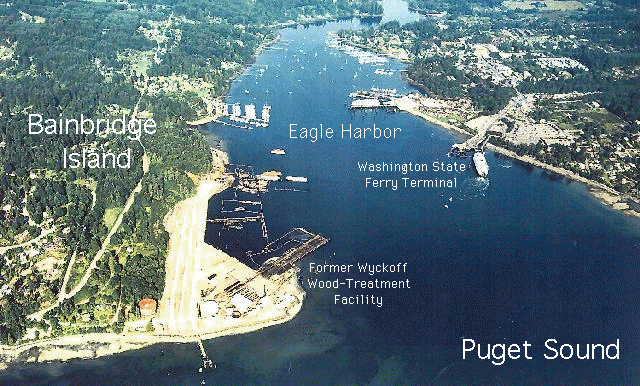
Fig. 1.
Aerial photo of Eagle Harbor and the location of selected reference sites.
Site History
The south shore of Eagle Harbor was the location of a wood treating operation for over 80 years. The former wood-treating facility, located at the mouth of Eagle Harbor, operated from 1903 to 1988. This facility and a former shipyard are the major sources of widespread sediment contamination in the 500-acre harbor. Marine sediments in Eagle Harbor are contaminated with polyaromatic hydrocarbons (PAHs) and other organics, as well as heavy metals such as mercury, copper, lead, and zinc from the shipyard, at levels toxic to marine life. On the Wyckoff facility, soil and groundwater are contaminated with creosote and its accompanying PAHs, pentachlorophenol (PCP), and other wood treatment compounds. An estimated one million gallons of creosote product remains in the site's soil and groundwater.
A shipyard operated on the north shore of the harbor. The wood treating facility, harbor, and other upland sources were included as one site on the National Priorities List (Superfund) on July 22, 1987.
About 2,000 people live within one mile of the site. The nearest residence is located less than 1/4 mile away. Land use in the area is largely residential and commercial. The harbor is heavily used by recreational boaters, "live-aboards," and ferry transport to and from Seattle. A local citizen group called "Association of Bainbridge Communities," or ABC, is receiving funding under EPA's Technical Assistance Grant Program to support their involvement in this site.
Fig. 2.
Eagle Harbor site and vicinity map.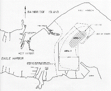
Contaminants
Bottom sediments in much of Eagle Harbor are contaminated with chemicals from wood treating and shipyard operations that are toxic to marine organisms. Specific contaminants found were creosote and mercury. A public health advisory recommending against eating seafood from Eagle Harbor was initiated in 1985 and is currently in effect.
Capping
Over a 6-month period ending in March 1994, EPA and the Corps of Engineers covered contaminated sediments in the East Harbor (Areas 1 and 2 on the map, Fig. 2) with a cap of clean sediment. Areas 1 and 2 are at water depths of 17 m and 13 m, respectively. The sediment was dredged from the Snohomish River as part of an annual project to keep the river channel open for ship navigation (Fig. 3).
Fig. 3.
Barge with load of Snohomish River capping sediments.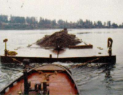
Fig. 4.
Split-hull barge in the process of depositing the capping sediments. Split-hull deposition is fast but can lead to uneven thickness of the cap layer.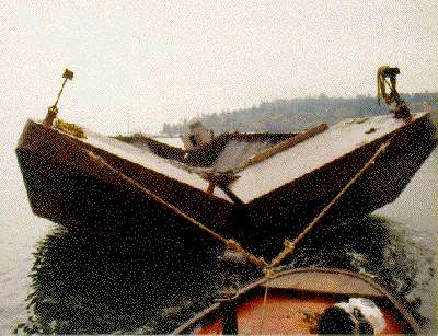
The sediment was placed using two methods: split-hull barge (Fig. 4) and hydraulic wash-off (Fig. 5). The material was placed in incremental layers over 54 acres of contaminated harbor sediments to provide clean habitat for marine life. The targeted cap thickness was 1 m, but post-construction surveying indicated slight variation of the final cap thickness over the site.
Video monitoring in March 1994 indicated that marine life has already begun to re-occupy the cap. Sea anemones, sea pens, gobies, starry flounder, and even a skate were observed.
Fig. 5.
Hydraulic wash-off as a process of depositing the capping sediments. The wash-off method allows for a more uniform placement but is slower than the split-hull dumping.
Current Status
Periodic monitoring of the cap is planned to assure the long-term effectiveness of the sediment cleanup. The current monitoring plan covers an initial 10-year period and includes measurements of cap thickness, suspended sediment chemistry and cap sediment chemistry, as well as qualitative observations of biological recolonization. Cap baseline monitoring was completed in the fall of 1995 and shows that the cap is functioning as planned.
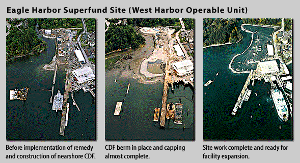
Fig. 6.
Sequential photos of the nearshore combined disposal facility process at Eagle Harbor